


Israeli forces have been laying tarmac on a key road in Gaza along its southern border – in what some commentators see as a signal that they’re not prepared to fully withdraw from the territory any time soon.
The road has become a major sticking point in the negotiations for a new ceasefire and hostage release deal.
BBC Verify has analysed satellite imagery, photos and video that show the surfacing of a road along the narrow but strategically important strip of land running the length of Gaza’s border with Egypt, long known by its Israeli military codename: the Philadelphi Corridor.
Between 26 August and 5 September, satellite imagery captured at regular intervals shows fresh paving along a section of road extending 6.4km inland from the coast along the border fence.
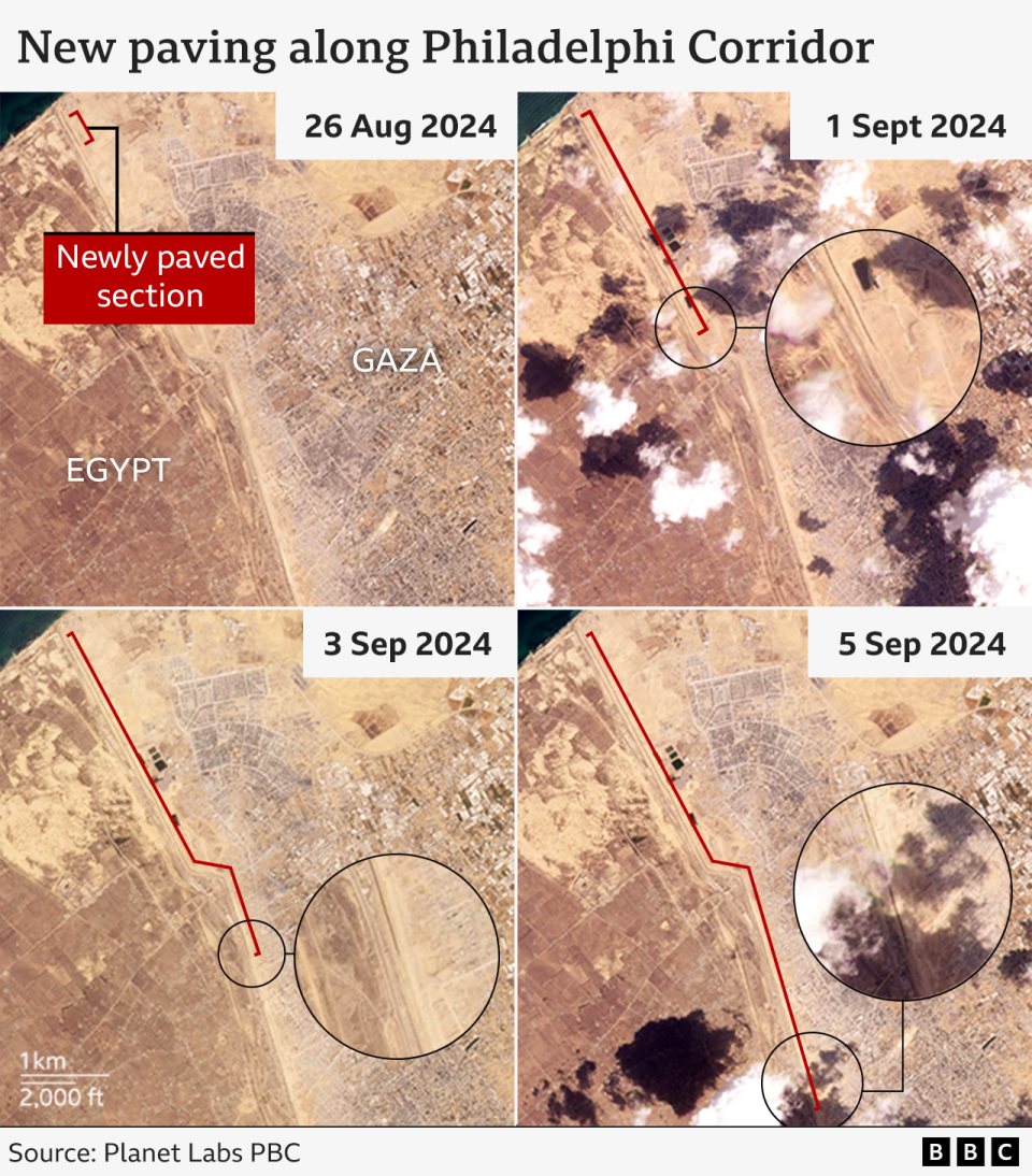
A video posted online on 4 September which shows construction work, reportedly that evening, along a stretch of the border fence.
Heavy machinery can be seen laying fresh tarmac wide enough for two large vehicles to pass.
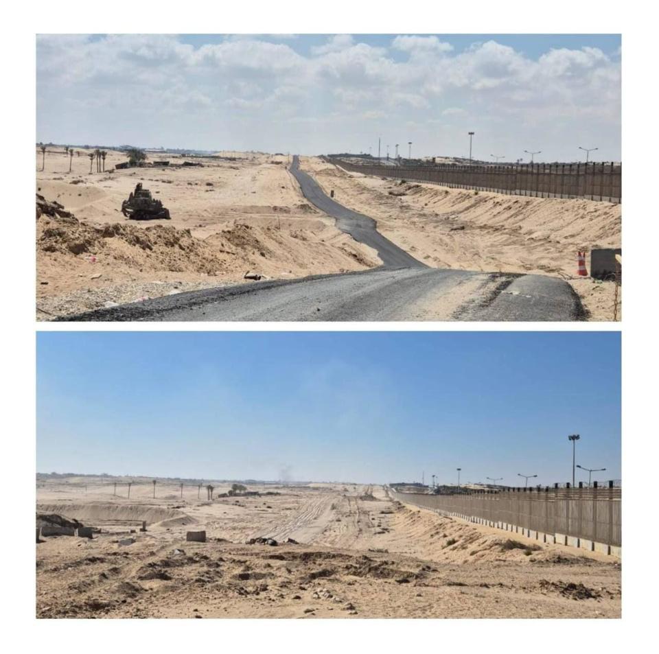
We’ve also compared two images below which show the laying of tarmac before and after. BBC Verify has confirmed the location and that they show the same stretch along the border fence.
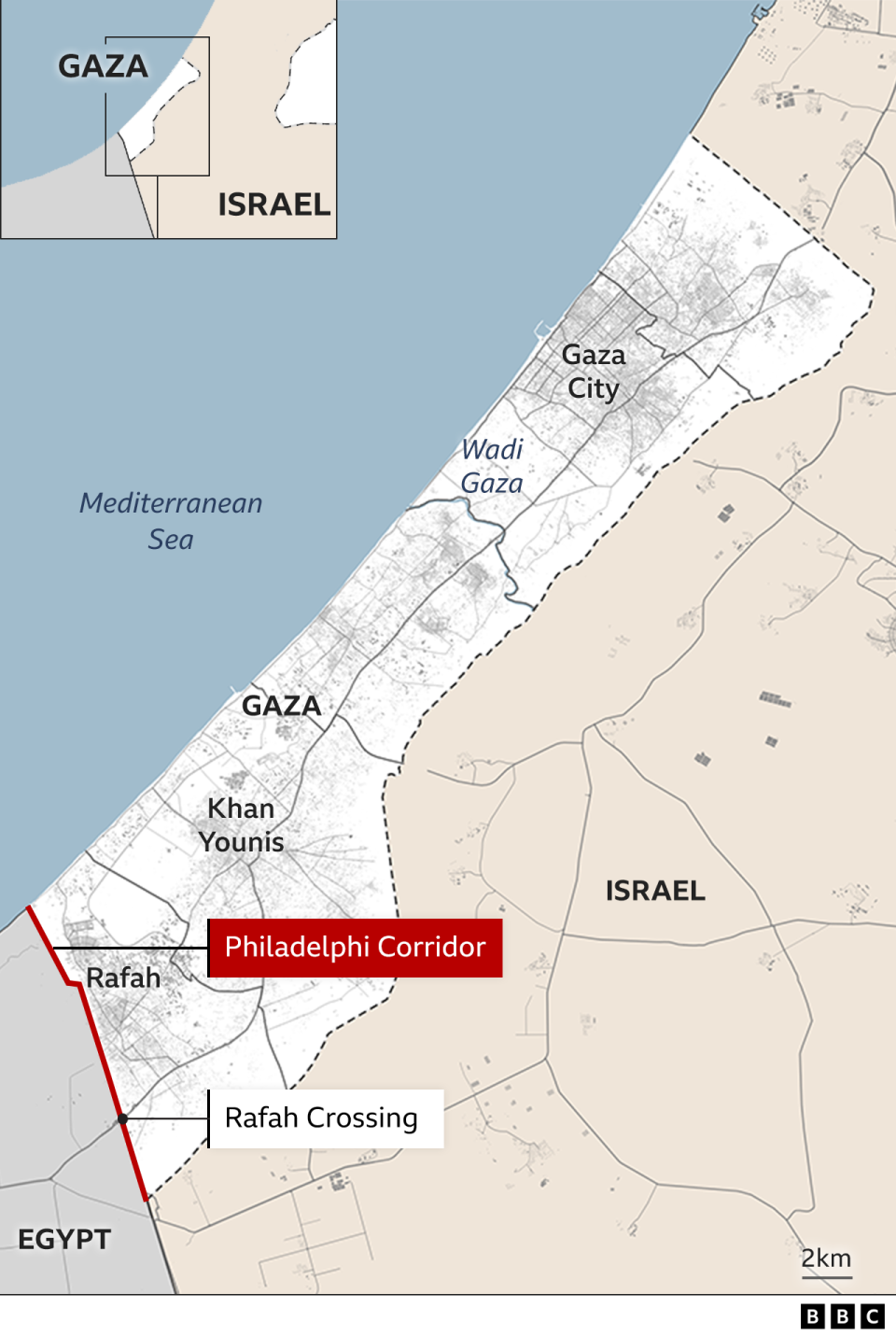
The corridor includes the Rafah crossing with Egypt – which has been Gaza’s only crossing not directly controlled by Israel and key for aid deliveries.
At 12.6 km (7.8 miles) long, it runs adjacent to the Egyptian border from the Kerem Shalom crossing to the Mediterranean Sea.
While the Israeli military calls it the Philadelphi Route or Axis, Palestinians often refer to it as the Salah al-Din Axis.
“It’s not a specific, demarcated area,” says Dr Andreas Krieg, a senior lecturer at the School of Security Studies at King’s College London. “It’s a conceptual line. It’s understood as land adjacent to the border.”
Israel previously pulled out of the area in 2005, when it withdrew its troops and settlers from Gaza.
But it re-entered the Philadelphi Corridor on 7 May this year with tanks and armoured personnel carriers (APCs) – months before starting to pave the road.
Troops seized control of the Rafah crossing and then began advancing north-west both along the corridor and into the nearby southern city of Rafah.
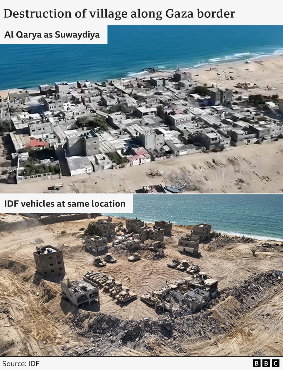
In the past four months, the IDF has destroyed hundreds of buildings near the corridor with air and artillery strikes, as well through controlled demolitions with explosives and bulldozers.
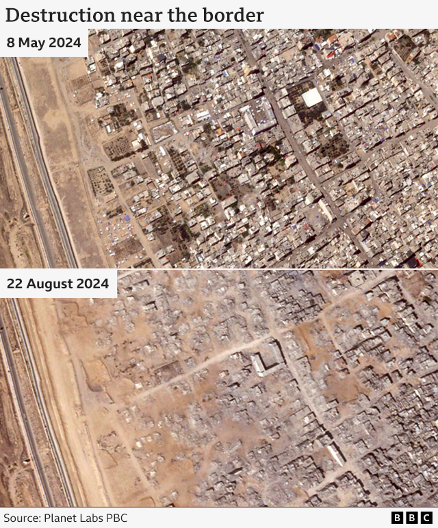
One village – Al Qarya as Suwaydiya – at the Mediterranean end of the border – has been flattened and now appears to be operating as an Israeli base.
Corridor important for peace talks
“Paving the road puts pressure on negotiators and mediators. The Israelis are trying to create a fait accompli,” says Dr Krieg.
“It also suggests that Israel is not going to withdraw entirely from the Gaza strip any time soon,” he says.
He cites a road built earlier this year by Israeli forces across northern Gaza – known as the Netzarim Corridor.
“If you look at the investments made in the Netzarim Corridor, it’s clear they have no intention of withdrawing anytime soon, they’ve got concrete barriers, forward operating bases with towers and walls – you don’t build those if you’re planning on withdrawing.”
Israeli Prime Minister Benjamin Netanyahu has described the Philadelphi Corridor as a “lifeline” for Hamas, and is adamant that Israel maintains a military presence there as a condition of any agreement.
At a press conference on Wednesday, he added: “You want to destroy Hamas’ military and governance capabilities, you can’t let Hamas rearm. So you have to control the corridor.”
The IDF’s chief of staff, Lt Gen Herzi Halevi, said on 14 August that “the Philadelphi Corridor is important because it deals with strengthening our position. We are preparing for all scenarios that the political level may decide.”
Retired Egyptian Major General Dr Samir Faraj, now a commentator on military strategy, said Israel’s aim was “psychological warfare… paving the road is a media war, a war in which Israel sends a message to different parties that they will not leave.“
We have asked the Israeli military why it is surfacing the road now but have not received a response.
Israel determined to destroy tunnels
Mr Netanyahu says Hamas has used tunnels underneath the corridor to smuggle weapons and people via Egypt before the 7 October attack on Israel, which triggered the war in Gaza.
He believes Israeli forces deployed there will prevent the group rearming and ensure it never again poses a threat.
In a visit to the corridor last month, Mr Gallant was quoted as saying: “We have destroyed 150 tunnels on the Philadelphi Corridor, stretching across the Gaza-Egypt border.”
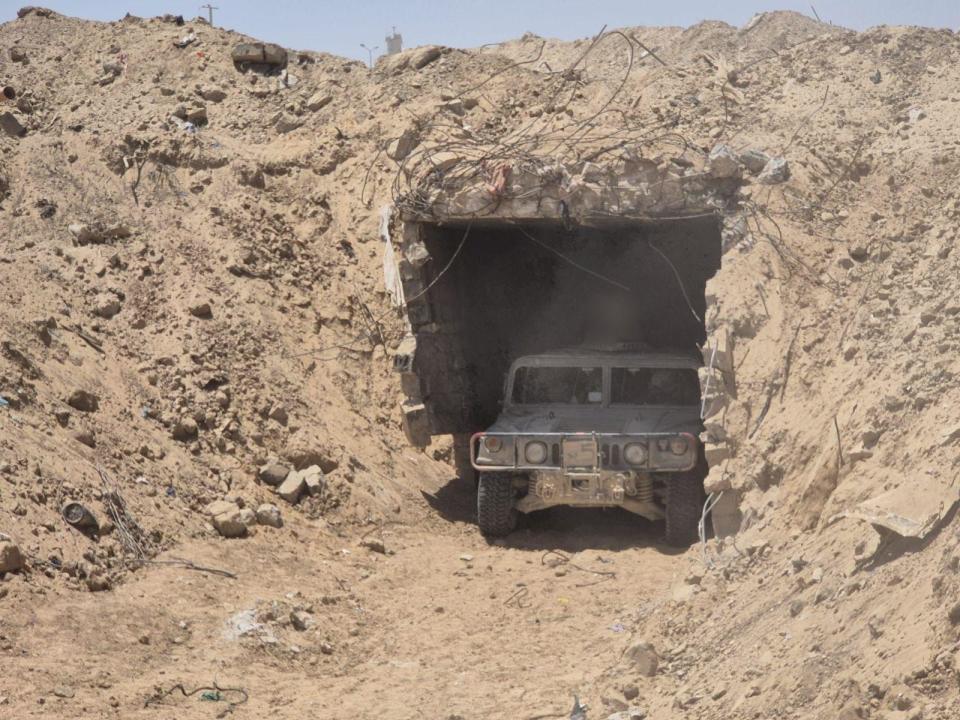
BBC Verify has located detonations in videos, shared by the IDF, to the Philadelphi Corridor – including one which it says shows “destruction of underground infrastructure” – but we are unable to confirm what is being destroyed.
We have also seen photos and video – again, shared by the IDF – of one substantial tunnel in the corridor.
All of these locations, as well as others along the border, show signs of major disturbances of the surface soil on satellite imagery.
Additional reporting by Lamees Altalebi and Joshua Cheetham

What do you want BBC Verify to investigate?


