


TAMPA, Fla. (WFLA) – We have one more day with an onshore wind pattern that brings extra humidity off the Gulf of Mexico. Temperatures climb into the low-mid 90s, but it’ll feel like 105-108 again.

Rain chances are relatively low for this time of the year. A few showers start near the coast around midday and spread inland. Overall, the rain chance is 30%.

A cold front arrives tomorrow with a slightly higher chance for a downpour. The storms build back toward the Gulf of Mexico as the cold front slides south in the evening. It’ll still be warm and humid with highs in the low-mid 90s.

Less humid air arrives Friday and sticks around for most of the weekend. The drier air limits rain chances to just 10% or less. It’ll still be hot in the sunshine, but heat index values stay below 100, which is as good as it gets in August.

Humidity levels and rain chances increase through next week.
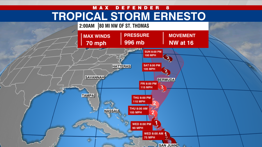
Tropical Storm Ernesto is strengthening as it begins to head north away from the Caribbean Islands. It may become a major hurricane as it nears Bermuda in the Atlantic.
Copyright 2024 Nexstar Media, Inc. All rights reserved. This material may not be published, broadcast, rewritten, or redistributed.
For the latest news, weather, sports, and streaming video, head to WFLA.


