


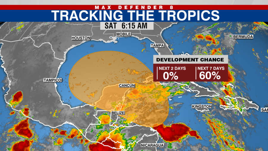
TAMPA, Fla. (WFLA) — A tropical depression could form next week as an area of low pressure in the Caribbean moves toward the Gulf of Mexico, the National Hurricane Center said early Saturday morning.
“Gradual development of this storm is possible, and a tropical depression could form as the system moves slowly to the north or northwest over the northwestern Caribbean Sea and into the southern Gulf of Mexico through the end of next week,” the NHC said.
However, regardless of development, the system is expected to produce heavy rains over portions of Central America during the next several days.
The system has a 60% chance of development over the next seven days.
Gordon remnants are still bringing showers and thunderstorms to the central subtropical Atlantic. Significant development is not expected while it meanders over the central subtropical Atlantic during the next couple of days.
The chance for development in the next two days is 10%.
Located about 700 miles northeast of the northern Leeward Islands, another area of low pressure is producing showers and a few thunderstorms, though conditions do not appear conducive for significant development over the next few days.
The NHC is also monitoring the eastern tropical Atlantic as a tropical wave is expected to move westward from the coast of Africa on Sunday or Monday with subsequent development possible next week as it moves west-northwestward over the eastern tropical Atlantic.
The chance for formation over the next seven days is 20%.
Watch Tracking the Tropics on Tuesdays at 12:30 p.m. ET/11:30 a.m. CT.
Be prepared with the 2024 Hurricane Guide and stay ahead of tropical development with the Tracking the Tropics newsletter.
Copyright 2024 Nexstar Media, Inc. All rights reserved. This material may not be published, broadcast, rewritten, or redistributed.
For the latest news, weather, sports, and streaming video, head to WFLA.


